

SEVERE WEATHER BULLETIN #1 FOR:Typhoon #QueeniePH
- TBN News

- Oct 1, 2018
- 1 min read
Tropical Cyclone: ALERT
ISSUED AT:5:00 PM, 01 October 2018
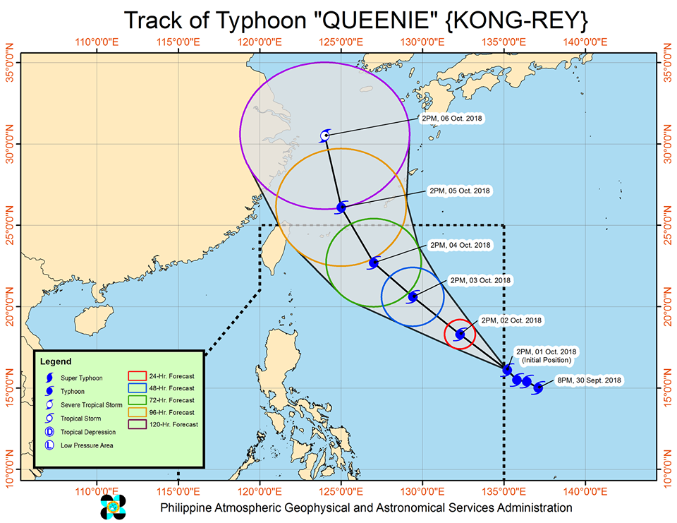
TYPHOON "KONG-REY" IS ABOUT TO ENTER THE PHILIPPINE AREA OF RESPONSIBILITY (PAR) AND IT WILL BE NAMED "QUEENIE".
Ty "Queenie" is expected to intensify further inside the PAR and will move West-Northwest to Northwest towards Southern Japan.
Expected to exit the PAR by Friday afternoon (04 October).
Light to at times moderate rains over Benguet, Nueva Vizcaya, Quirino, and Aurora until Thursday (03 October).
Sea travel is risky over the seaboards of Northern Luzon.
Location of eye/center: At 4:00 PM today, the eye of Typhoon "QUEENIE" was located based on all available data at 1,170 km East Northeast of Borongan City, Eastern Samar (OUTSIDE PAR) (16.4 °N, 135.1 °E)
Strength: Maximum sustained winds of 160 km/h near the center and gustiness of up to 195 km/h
Forecast Movement: Moving Northwest at 15 km/h
Forecast Positions:
24 Hour(Tomorrow afternoon): 1,120 km East of Tuguegarao City, Cagayan(18.3°N, 132.3°E)
48 Hour(Wednesday afternoon):775 km East of Basco, Batanes(20.6°N, 129.4°E)
72 Hour(Thursday afternoon): 580 km East Northeast of Basco, Batanes(22.7°N, 127.0°E)
96 Hour(Friday afternoon):700 km North Northeast of Basco, Batanes (OUTSIDE PAR)(26.1°N, 125.0°E)
120 Hour(Saturday afternoon):1,135 km North of Basco, Batanes (OUTSIDE PAR)(30.5°N, 124.0°E)
NO TROPICAL CYCLONE WARNING SIGNAL
The public and the disaster risk reduction and management council concerned are advised to take appropriate actions and watch for the next update to be incorporated in the 4 PM Public Weather Forecast and in the next Severe Weather Bulletin to be issued at 11 PM today.
SOURCE: Dost_pagasa


Comments